
Accurate external works quantities from site plans are the foundation of any credible UK construction estimate. These quantities cover every measurable element outside a building's footprint: site preparation, roads, paths, pavings, landscaping, fencing, drainage, and external services. The governing framework is RICS NRM2, which standardises how each element is measured, described, and presented in a Bill of Quantities. Get this right and your cost plan holds. Get it wrong and the consequences compound through every subsequent stage.
Table of Contents
- What are external works quantities and how are they measured?
- How does RICS NRM2 Group Element 8 classify external works?
- Which measurements on a site plan matter most for quantity takeoff?
- What tools and resources support external works quantity extraction?
- How to carry out a digital takeoff for external works: UK best practice
- Quantiflow cuts the time from drawing to priced BoQ
- Key takeaways
What are external works quantities and how are they measured?
External works quantities are the calculated amounts of construction elements located outside a building's structural envelope, expressed in units that allow direct pricing. RICS NRM2 defines the standard units for each element type:
- Area (m²): paving, grassed areas, topsoil stripping, soft landscaping
- Linear metres (m): fencing, kerbing, drainage runs, edging
- Cubic metres (m³): excavation, fill, topsoil, imported material
- Count (nr): gullies, manholes, trees, bollards, gates
Measurement is carried out from site plans, general arrangement drawings, and associated details. Digital takeoff is now the preferred methodology for most UK practices, offering speed and a traceable audit trail. Manual measurement from scaled drawings remains valid for smaller schemes or where digital files are unavailable, but it carries a higher risk of cumulative error. Accurate external works measurement directly informs cost planning at RIBA Stage 3 and beyond, so the discipline applied at takeoff stage has a direct bearing on tender reliability.
How does RICS NRM2 Group Element 8 classify external works?
Group Element 8 of RICS NRM2 provides the structured classification that underpins all external works measurement in UK practice. Each sub-element has defined scope, measurement rules, and unit conventions:
- 8.1 Site preparation works: clearance, demolition of existing structures, tree removal, topsoil strip
- 8.2 Roads, paths, pavings, and surfacings: carriageways, footpaths, hardstandings, car parks, kerbing, edging
- 8.3 Soft landscaping, planting, and irrigation systems: turfing, seeding, planting of trees and shrubs, irrigation pipework
- 8.4 Fencing, railings, and walls: boundary fencing, retaining walls, screen walls, gates
- 8.5 External fixtures: street furniture, cycle stands, bins, signage, external lighting columns
- 8.6 External drainage: surface water drainage, foul drainage, soakaways, attenuation tanks
- 8.7 External services: gas, water, electricity, telecoms, and ducting runs to the building
Working through each sub-element in sequence prevents omissions and makes cost allocation straightforward. A quantity surveyor who structures their takeoff against these categories can map quantities directly to a priced BoQ without reworking the data. Resources such as RICS isurv provide detailed guidance notes for each sub-element, which are worth consulting when scope boundaries are ambiguous.
Which measurements on a site plan matter most for quantity takeoff?
A site plan carries more measurement data than most surveyors extract on a first pass. The critical information for external works measurements falls into several distinct categories:
- Property boundaries and site area: defines the total extent of works and the limit of measurement
- Building footprint and setbacks: establishes the area available for external works by subtraction
- Road and access dimensions: carriageway widths, turning circles, visibility splays, and gradients
- Landscaping zones: soft and hard areas delineated by boundary lines or hatching
- Drainage layout: pipe runs, invert levels, manhole positions, and outfall locations
- Spot levels and contour lines: essential for calculating cut and fill volumes in earthworks
Spot levels and contours deserve particular attention. Earthwork volumes are calculated either by the cross section method, which measures profiles perpendicular to a centre line at regular intervals, or by the spot level grid method, which divides the site into a grid and records existing versus proposed levels at each intersection. Both methods depend entirely on the quality of level data shown on the drawings.
Cross-referencing the site plan against drainage layout drawings, landscape plans, and sections is not optional. Dimensions shown on one drawing are frequently absent from another, and a takeoff based on a single drawing will almost always undercount.

Pro Tip: Always verify the drawing scale before measuring. A PDF printed at a non-standard size will produce a false scale reading. Check the stated scale against a known dimension on the drawing, such as a door opening or grid line spacing, before committing any measurements.
What tools and resources support external works quantity extraction?
Digital takeoff software has transformed site plan quantity takeoff by enabling direct measurement from PDF drawings or BIM models, with quantities extracted by area, linear metre, volume, or count. The key capabilities to look for in any platform include:
- Scale calibration: the ability to set and verify drawing scale before measurement begins
- Area measurement tools: polygon and auto-boundary tools for paving, landscaping, and site preparation
- Linear measurement: path tools for fencing, kerbing, drainage runs, and service routes
- Volume calculation: cut and fill tools that accept spot level grids or cross section data
- Count tools: click-to-count for manholes, gullies, trees, and fixtures
- BoQ export: structured output that maps to NRM2 element codes
AI-assisted platforms go further by cross-referencing multiple drawings automatically, flagging inconsistencies between plan views and details. This is particularly valuable for external works, where drainage and services information is often spread across several drawing sets. For contractors exploring how AI is being applied to automated measurement workflows more broadly, AI dispatch for contractors illustrates the direction the industry is moving.
Manual methods using a scale rule and printed drawings remain appropriate for very small schemes or feasibility-stage estimates where drawing quality does not justify digital investment. For anything above a modest residential extension, the time saving and error reduction from digital tools make them the practical default. RICS isurv provides authoritative guidance on measurement standards and best practice, and is the first reference point when NRM2 interpretation questions arise.
How to carry out a digital takeoff for external works: UK best practice
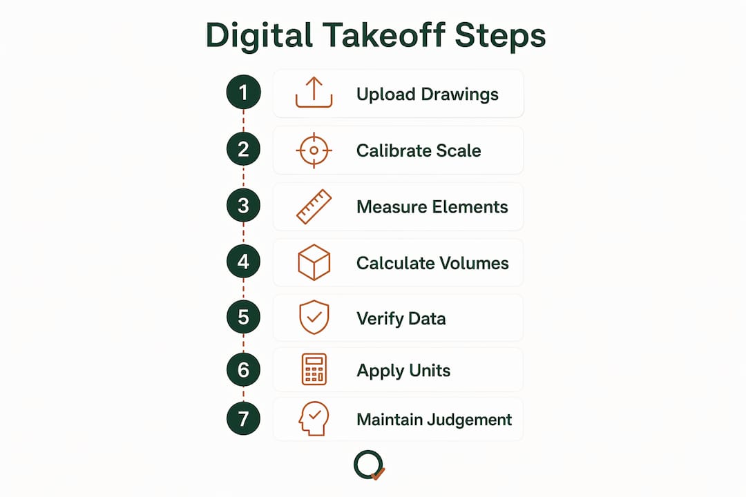
A structured approach to quantity surveying for site plans produces consistent, auditable results. The following workflow reflects current UK practice aligned with NRM2 Group Element 8.
1. Upload and organise drawings
Load all relevant PDFs into your takeoff platform: site layout plan, drainage layout, landscape plan, sections, and any external works details. Label each drawing clearly and confirm the revision status before measuring.
2. Calibrate the scale
Set the drawing scale using a known dimension. Reading PDF drawings accurately depends on this step being correct. A 1% scale error compounds across every subsequent measurement.
3. Measure by NRM2 sub-element
Work through Group Element 8 in sequence. Measure site preparation areas first, then roads and pavings, then soft landscaping, fencing, fixtures, drainage, and services. Using the NRM2 structure as your measurement order prevents omissions and makes the output directly usable in a BoQ.
4. Calculate earthwork volumes
For cut and fill, apply the spot level grid method where spot levels are available on the drawings. Record existing and proposed levels at each grid intersection, calculate the difference, multiply by the grid cell area, and sum the results. Where only contours are available, use the cross section method at regular intervals.
5. Verify and cross-check
Cross-checking measurements against multiple drawing views catches errors that a single-drawing takeoff will miss. Validate paving areas by checking they are consistent with the site area minus the building footprint and any soft landscaping zones. Confirm drainage run lengths against both the site plan and the drainage layout drawing. Where dimensions are missing, note the assumption made and flag it for design team clarification.
6. Apply standard units and conversion factors
NRM2 requires standard measurement units: m² for area, m for linear items, m³ for volume, and nr for counted items. Convert any imperial dimensions shown on older drawings before entering quantities. One linear foot equals 0.3048 m; one square foot equals 0.0929 m².
7. Maintain professional judgement
Automation accelerates measurement but does not replace the surveyor's responsibility for the output. Review AI-generated quantities against your own sense of scale and project context. If a calculated paving area looks implausible relative to the site plan, investigate before accepting it.
Pro Tip: Structure your takeoff file to mirror the NRM2 Group Element 8 sequence from the outset. Quantities measured in NRM2 order feed directly into a structured BoQ without reformatting, saving time at pricing stage and making peer review straightforward.
Common discrepancies arise from drawing revisions issued mid-takeoff, inconsistent dimensions between plan and section views, and spot levels that do not reconcile with finished floor levels shown on the architectural drawings. A revision-control log and a final sense-check against the overall site area will catch most of these before they reach the estimate. For residential schemes, the residential quantities guide covers scheme-specific workflows in detail.
Quantiflow cuts the time from drawing to priced BoQ
Quantity surveyors who work through the methodology above know the bottleneck: it is not the measurement itself, it is the time spent organising drawings, calibrating scales, and reformatting outputs into a BoQ structure that a contractor can price. That is the gap Quantiflow fills.

Quantiflow is a UK SaaS platform built specifically for SME quantity surveyors, builders, and architects. It automates NRM2-aligned takeoffs directly from PDF drawings, using an AI cross-referencing engine to reconcile quantities across multiple drawing sheets and flag inconsistencies before they reach the estimate. External works quantities are structured against Group Element 8 automatically, so the output maps straight to a priceable BoQ without manual reformatting. Plans start from £39 per month for solo practitioners, with Business and Enterprise tiers for larger teams.
The platform is built to support your professional judgement, not replace it. Every quantity is traceable to its source drawing, and the structured output gives you a clear audit trail for client review. Measured twice. Priced once. See what Quantiflow can do for your external works takeoffs.
Key takeaways
Accurate external works measurement from site plans requires NRM2 compliance, structured digital workflows, and active verification at every stage.
| Point | Details |
|---|---|
| NRM2 Group Element 8 | Classifies external works into seven sub-elements, from site preparation to external services, providing the measurement framework for UK BoQs. |
| Standard measurement units | NRM2 requires m² for area, m for linear items, m³ for volume, and nr for counted items across all external works categories. |
| Earthwork volume methods | Cut and fill quantities are calculated using either the cross section method or the spot level grid method, both dependent on level data from drawings. |
| Verification is mandatory | Cross-checking quantities against multiple drawing views and validating scales reduces discrepancies before they reach the cost plan. |
| Quantiflow automates the process | Quantiflow produces NRM2-aligned external works takeoffs from PDF drawings, with AI cross-referencing and direct BoQ output from £39 per month. |